Input Data
To generate all the input forcing data required to run iSnobal, the following measured or derived variables are needed
- Air temperature
- Vapor pressure
- Precipitation
- Wind speed and direction
- Cloud factor
This page documents a more detailed description of each of the input variables, the types of input data that can be used for SMRF, and the data format for passing the data to SRMF.
Variable Descriptions
- Air temperature [Celcius]
- Measured or modeled air temperature at the surface
- Vapor pressure [Pascals]
- Derived from the air temperature and measured relative humidity. Can be calculated
using the IPW utility
sat2vp. - Precipitation [mm]
- Instantaneous precipitation with no negative values. If using a weighing precipitation gauge that outputs accumulated precipitation, the value must be converted.
- Wind speed [meters per second]
- The measured wind speed at the surface. Typically an average value over the measurement interval.
- Wind direction [degrees]
- The measured wind direction at the surface. Typically an average value over the measurement interval.
- Cloud factor [None]
- The percentage between 0 and 1 of the incoming solar radiation that is obstructed by clouds.
0 equates to no light and 1 equates to no clouds. The cloud factor is derived from the
measured solar radiation and the modeled clear sky solar raditation. The modeled clear sky
solar radiation can be calculated using the IPW utility
twostream.
Types of Input Data
All types of input data to SMRF are assumed to be point measurements. Therefore, each measurement location must have a X, Y, and elevation associated with it.
Weather Stations
Generally, SMRF will be run using measured variables from weather stations in and around the area of interest. Below are some potential websites for finding data for weather stations:
Gridded Model Output
Gridded datasets can be used as input data for SMRF. The typical use will be for downscaling gridded weather model forecasts to the snow model domain in order to produce a short term snowpack forecast. In theory, any resolution can be utilized, but the methods have been tested and developed using Weather Reserach and Forecasting (WRF) at a 1 and 3 km resolution. Each grid point will be used as if it were a weather stations, with it’s own X, Y, and elevation. Therefore, the coarse resolution model terrain can be taken into account when downscaling to a higher resolution DEM.
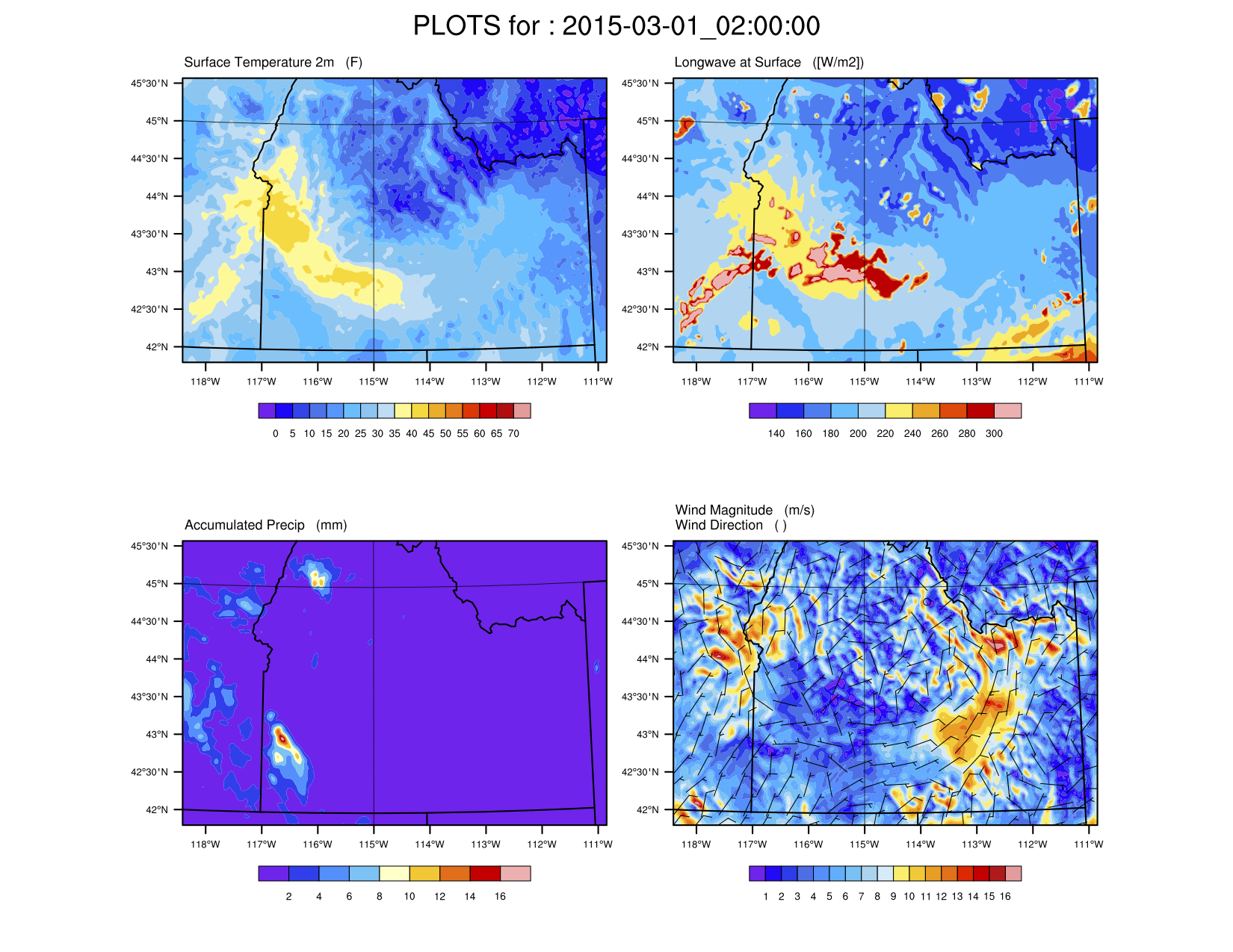
Fig. 1 Using WRF as a gridded dataset for SMRF.
See Havens et al. (in prep) for more details and further discussion on using WRF for forcing iSnobal.
Data Format
CSV Files
Each variable requires its own CSV file plus a metadata file. See smrf.data.csv_data for more information.
The variable files must be structured as:
| date_time | ID_1 | ID_2 | … | ID_N |
|---|---|---|---|---|
| 10/01/2008 00:00 | 5.2 | 13.2 | … | -1.3 |
| 10/01/2008 01:00 | 6.3 | NAN | … | -2.5 |
| … | … | … | … | … |
| 09/30/2009 00:00 | 10.3 | 21.9 | … | 0.9 |
date_time must be chronolgical and in any format that pandas.to_datetime() can parse. Errors
will occur on import when pandas cannot parse the string. The best format to use is MM-DD-YYYY HH:mm.
The column headers are the station ID numbers, which uniquely identify each station. The station ID is used throughout SMRF to filter and specify stations, as well as the metadata.
The data for each station is in the column under the station ID. Missing values can be included as
either NAN or blank, which will be converted to NaN in SMRF. Missing data values will not
be included in the distribution calculations.
The metadata CSV file tells SMRF important information about the location for each stations. At a minimum the metadata file must have a primary_id, X, Y, and elevation. The locations must be in UTM and the elevation is in same units as the DEM (typically meters).
| primary_id | X | Y | elevation |
|---|---|---|---|
| ID_1 | 625406 | 4801625 | 1183 |
| ID_2 | 586856 | 4827316 | 998 |
| … | … | … | … |
| ID_N | 641751 | 4846381 | 2310 |
Example data files can be found for WY 2009 for the Boise River Basin in test_data/stationData.
MySQL Database
The MySQL database is more flexible than CSV files but requires more effort to setup. However,
SMRF will only import the data and stations that were requested without loading in additional
data that isn’t required. See smrf.data.mysql_data for more information.
The data table contains all the measurement data with a single row representing a measurement
time for a station. The date column (i.e. date_time) must be a DATETIME data type with
a unique constraint on the date_time column and primary_id column.
| date_time | primary_id | var1 | var2 | … | varN |
|---|---|---|---|---|---|
| 10/01/2008 00:00 | ID_1 | 5.2 | 13.2 | … | -1.3 |
| 10/01/2008 00:00 | ID_2 | 1.1 | 0 | … | -10.3 |
| 10/01/2008 01:00 | ID_1 | 6.3 | NAN | … | -2.5 |
| 10/01/2008 01:00 | ID_2 | 0.3 | 7.1 | … | 9.4 |
The metadata table is the same format as the CSV files, with a primary_id, X, Y, and elevation
column. A benefit to using MySQL is that we can use a client as a way to group multiple
stations to be used for a given model run. For example, we can have a client named BRB, which
will have all the station ID’s for the stations that would be used to run SMRF. Then we can
specify the client in the configuration file instead of listing out all the station ID’s. To use
this feature, a table must be created to hold this information. Then the station ID’s matching
the client will only be imported. The following is how the table should be setup. Source is used
to track where the data is coming from.
| station_id | client | source |
|---|---|---|
| ID_1 | BRB | Mesowest |
| ID_2 | BRB | Mesowest |
| ID_3 | TUOL | CDEC |
| … | … | … |
| ID_N | BRB | Mesowest |
Please contact Scott Havens (scott.havens@ars.usda.gov) if you’d like to use a MySQL database but need help setting up the database and tables to work with SMRF. We can provide scripts that will help create the database.
Gridded Dataset
Gridded datasets can come in many forms and the smrf.data.loadGrid module is meant to import
gridded datasets. Currently, SMRF can ingest WRF output in the standard wrf_out NetCDF files. SMRF
looks for specific variables with the WRF output file and converts them to the related SMRF values.
The grid cells are imported as if they are a single measurement station with it’s own X, Y, and
elevation. The minimum variables required are:
- Times
- The date time for each timestep
- XLAT
- Latitude of each grid cell
- XLONG
- Longitude of each grid cell
- HGT
- Elevation of each grid cell
- T2
- Air temperature at 2 meters above the surface
- DWPT
- Dew point temperature at 2 meters above the surface, which will be used to calculate vapor pressure
- GLW
- Incoming thermal radiation at the surface
- RAINNC
- Accumulated precipitation
- CLDFRA
- Cloud fraction for all atmoshperic layers, the average will be used at the SMRF cloud factor
- UGRD
- Wind vector, u component
- VGRD
- Wind vector, v component